Dalton Villages, Towns, and Cities Worldwide
There are many places in
the world with the name of Dalton. Listed below are most of these, with maps
and with a little history added.
Complied by Rodney G. Dalton.

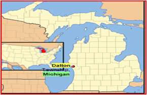
Dalton
Mills, Ontario, Canada
From 1921-1949 Dalton mills in the Algoma District of Ontario, Canada grew out to be the largest producer of railway ties in the entire British Commonwealth. The large mill stood on east side while the town sat on the west side pf the river (or bridge). A spur ran 3 miles back to the CPR at Dalton Station, where a smaller community grew up around the station and the extensive lumber yards on the CPR mainline. Dalton Mills contained a school, a large general store and Post office, company offices, hotel, small hospital, rec. centre, Catholic church, Anglican church, pool hall, and 80 homes foe employees. here was also a large 100 room bunkhouse near the mill. Its population peaked at a healthy 600 permanent residents. But the mill burnt down in 1949, and the timber berths were bare, and so the community faded to nothing by 1951.
History of Dalton Mills;
In 1921, the Austin and
Nicholson Lumber Company decided to build a new mill along the Shikwampkwa
Lake. Their first mill had already been built in nearby Nicholson back in 1903.
This new mill would be the most advanced mill to date. It would have to be,
after all their lumber was in steady demand as they were the largest producer
of railway ties in Canada. The nearby mill at Nicholson was putting out lumber
as quickly as possible, and the new mill would help meet the backlog of up to
700,000 railway ties required to be produced.
The company went all out, adding indoor toilets to the homes, a recreation centre (est. 1928) which included a bowling alley, pool tables, ice-cream parlor, and barber shop. Other buildings included: hospital, hotel, Catholic and Anglican churches and a movie theater named The Plaza, built in 1927. The town also contained a school, general store and post office.
For accommodations, a two story boarding house was constructed with over 100 rooms. By 1927 there would be more than 80 buildings on the site and approximately 600 residents.
The mill itself stood on the Eastern side of the Shamkakwa River, the town on the other side. A bridge connected the town to the mill. As was the fate with many mills constructed of wood, fire destroyed the mill in 1949. It would be replaced with another mill in Dalton Station in 1962. As for the settlement of Dalton Mills, it was deserted by 1951.
In June of 1946 Dan Tessier, a trapper and employee of the Austin Lumber Company was murdered about 9 miles from Dalton Mills. He was shot while leaving his trapper's cabin on the Shikwamka River. No one was ever charged with the murder but it appeared to have been as a result of a dispute or disputes over area trap lines.
Dalton Station, Ontario,
Canada
Was the sister village to
Dalton Mills. It was situated along the CP Rail line between White River and
Chapleau. It's purpose was to ship out the lumber cut at Dalton Mills. The town
stood 3 miles north of Dalton Mills and began with a mill and storage yards
which could handle 100,000,000 board feet of lumber. In addition a pulpwood
mill began operating in 1915.
The town grew to include a Catholic Church (now a blue home), post office (established 1925, closed in 1968), gas station, church, store, bunkhouse and homes. The original line between Dalton Station and Dalton Mills was a railway line, until the highway was constructed in 1966.
Dalton Station's population was approximately 150 residents but declined after the mill burned in 1949. A new mill would be built in 1962 and would operate until 1979. The newer electric mill didn't require as many employees as its predecessor which further reduced the town's population.
Today you will find a half dozen original homes and the former Catholic Church (the blue house). They are used seasonally. The station was torn down many years ago and the usual workers building stands in its place.

Dalton,
Kansas
Is located in eastern Sumner county just south of US 160. Turn south from 160 onto the paved road to tour the town. There is a picturesque old metal grain elevator beside the tracks and a rusting railroad sign announcing "Dalton". There don't seem to be any retail businesses. The most exciting part of our last visit was getting a sleepy dog to move out of the street.

Dalton,
Massachusetts
Berkshire Co. was first granted in 1764 under the name Chiswick, originally encompassed Lisbon, Littleton, and Dalton. In 1770, a portion of the grant was renamed Apthorp, after relatives of the Wentworths. At that time, the grantees were bought out by Colonel Moses Little, commander of the 24th Massachusetts Bay Regiment and relative of the Apthorp family. In 1784, the grant was divided into two towns, Littleton, named for the Colonel, and Dalton, which bears the name of the Colonel's great-grandson, Tristram Dalton, a prominent colonial merchant and classmate of Governor John Wentworth at Harvard.
Some history of Dalton, Massachusetts;
Once a part of Littleton, the town went through several name changes. Starting in 1764 as Chiswick, after the Duke of Devonshires Castle, in 1770 the name changed to Apthorp, honoring the Apthorp family. Finally in 1784 it was changed to Dalton, for Tristram Dalton, one of New Englands foremost colonial merchants. Moses Little & Co. secured a charter for approximately 10,000 acres on January 18, 1770. After Dalton and Tracy purchased 6,000 acres from the Littles, the entire tract of 16,455 acres became incorporated on Nov. 4, 1784 and took its name from Tristam Dalton. Some time later, Dalton offered two 160 acre parcels to anyone who would make a road passable for a one horse wagon between the towns of Haverhill and Lancaster. A man named Moses Blake cleared a road that follows the Connecticut River and is known as Route 135 today. In June of 1754, Capt. Peter Powers, who commanded an expedition to Coos County, commented in his journal about the good growth of timber, abundant brooks, and land which was as good as ever seen by any of us. Upon arriving at the mouth of the Johns River, the Powers party called it Starks River in honor of Ensign John Stark who was captured by the Indians there.

Dalton, Georgia
In the Ridge and Valley section of the state, Dalton spreads across the valley to rugged Rocky Face Ridge. 1847 is a pivotal year for the citizens of Cross Plains. In honor of founder Edward Dalton White the city changes the name to Dalton. That same year the Western and Atlantic Railroad is completed to the small town. Its location near the railroad would greatly affect the destiny of this north Georgia town.
The growth of Dalton is astonishing. Completion of the W&ARR to Chattanooga, Tennessee in 1850 creates the first rail system to the area west of the Appalachians. In 1851 Dalton is named the seat of government for newly created Whitfield County and a railroad depot is completed the following year. Built in the center of town the depot still stands, one of the few antebellum structures in Northwest Georgia.
The Civil War in Dalton, Georgia:
During The Great Locomotive Chase (April 12, 1862) the General quickly passes through Dalton. A few moments later the Texas slows as it approaches the depot and drops Edward Henderson off. The 18 year-old Dalton telegraph operator then sends a message to General Ledbetter in Chattanooga informing him of the approaching spies.
While Dalton was pro-Union prior to the outbreak of The Civil War, after Georgia votes to secede in January 1861 only a few Unionists could be found. One suspected northern sympathizer was Ansley Blunt, postmaster and first mayor of the city whose home, the Blunt House, stands south of the downtown area.
Many of the men who would fight at Chickamauga (September 1863) arrived in Dalton by train, passing through the depot. From 1862 until 1864 Dalton serves as a front-line hospital town, sending more critically wounded men to hospitals in Marietta and Atlanta.
Following the disaster at Missionary Ridge (Chattanooga, November 1863), Army of Tennessee Commander Braxton Bragg establishes his headquarters here. Bragg would leave Dalton shortly after being relieved of the command that Joseph E. Johnston would assume. For the next five months the Confederate Army uses the town as a base camp, building a nearly impenetrable line at Rocky Face, a ridge to the west. In February 1864, the Army of the Cumberland attacks the entrenchments, attempting to prevent Johnston from re-enforcing Leonidas Polk in Meridian. Generally referred to as First Dalton, this attack forewarned the Union Army of the difficulty of breaking the Confederate line. In May 1864, Thomas once again tried to launch attacks at both Buzzard's Roost (Mill Creek Gap) and Dug Gap to no avail (called the Battle of Rocky Face). Unable to successfully breach the Rebel line he joins John McPherson in an attack on Resaca. Threatened with the Union Army to his rear, the Confederate commander withdraws to the south, once again passing through the Dalton depot.
After the Fall of Atlanta (September 1864), the city of Dalton is unsuccessfully targeted by John Bell Hood at the beginning of the Nashville Campaign (Second Dalton). Solidly in Union hands for the remainder of the conflict, Dalton began to rebuild. One key to the post war expansion in Dalton was the addition of a rail line to Rome, making Dalton a hub of rail activity.

Dalton,
Pennsylvania
History of Dalton's name: "The Bailey family settled in this part of Abington township around 1801, and the area took on the name Bailey Hollow. Hollow, by the way, means 'small valley.' Helen and John Villaume of Clarks Summit recalled the story behind the name change: In the late 1860's, Dr. J.C. Miles of Bailey Hollow, among others, felt that the name sounded unbecoming for a town of increasing prominence. The railroad would soon choose whether to run through Bailey Hollow or Waverly, and locals felt the 'hollow' name might chase the rail line away. Dr. Miles chose the new name in 1871 after a visit from Dr. Edward Dalton, a civil war surgeon and superintendent of the New York City Board of Health. The Scranton press praised the named change and encouraged Tunkhannock to consider a similar move."

Dalton,
Ohio
When the business district of the village of Dalton burned down in 1894, some folks may have predicted the end of the little town. But Dalton - located in eastern Wayne County - has prospered, growing to a current population of more than 1,600, with many more people residing in the rural areas outside town.
Considering its diminutive size, it may be surprising to learn that the village of Dalton was actually formed from three separate villages! With the merging of early-18th century settlements Dover, Sharon and Middletown in 1856, Dalton was born. Accounts vary as to how the name came about. Some say letters from the three previous settlements were used to form the word; other accounts point to the suggestion of a prominent townsman from Dalton, Georgia.
In its early days, Dalton was known primarily for its location (on the old State Road, a major highway to the west) and for two prominent businesses.
From 1882 to 1925 Dalton was a major stop on the Wheeling and Lake Erie Railroad, carrying both passengers and merchandise. One of the area's first log structures, the Eagle Tavern, served as a stagecoach stop and hotel long before the trains came through. Today it has been restored and moved to the east end of town, serving as the home of the Dalton Historical Society.

Dalton
district;
A subdivision in Salt Lake City, Utah

Dalton City,
Moultrie County, Illinois
Dalton City is a village in Moultrie County, Illinois, United States. It is in the center of the state near the Macon County line, located along Route 121 at its intersection with Route 128 and between the larger villages of Bethany and Mount Zion. The population was 581 at the 2000 census.
Brief History of Dalton City, Illinois
Dalton City is in Dora Township of Moultrie County. The original plat contained 20 acres in sections 30 & 31 and was laid out by Thomas Dalton (from England) and James Roney. Surveyed in the fall of 1871 and recorded on April 17, 1872. The village was incorporated under Illinois State laws on September 15, 1877.
The first settlements were made in 1852 by Harvey and Madison Walker. Edward Bresnan settled in 1858 on Section 2. Edward was from Ireland, and many Irish immigrants moved to the area. After 146 years, relatives of the Bresnan and Henneberry Families still reside and farm in the Dalton City area.

Dalton;
in Chariton County, Missouri, named for William Dalton.
The population in the 2000 census was 27 people

Dalton,
Wisconsin;
Dalton, Wisconsin is an unincorporated community in the southwest corner of Green Lake County, Wisconsin in the Kingston township. It is located on Wisconsin Highway 44. It uses ZIP code 53926. The surrounding countryside is mainly occupied by dairy farmers and Amish.

Dalton,
Cheyenne County, Nebraska
In 1899 the Nebraska, Wyoming, & Western Railroad was certified and surveying crews staked its route through Cheyenne County. Dalton was one of the work stations. In January 1900 the railroad purchased 150' strip of land from the 1867 land grant belonging to the Union Pacific. By fall there was a daily freight and passenger service north to Deadwood and south to Denver. The railroad erected a depot, section house, water tank, and stock pens. The original depot burned and was rebuilt on the east side of the track. In 1961 after service was discontinued, the buildings were sold and made into a home and specialty shop. The depot grounds are now a nice little park.
A 1908 ad reads: "...Dalton, a year old on February 24...there never was another town in the state which made as rapid a growth as this town. Two elevators, hotels, livery barns, churches, and several stores were started in sixteen months. Land is level, having a rich black soil five feet deep with a clay subsoil underneath. There never was a better chance for men to get close to a good town and have better soil than this...the price of land...from $16 to $22.50 per acre..."

Dalton
Gardens, Idaho
Dalton Gardens, Idaho, in Kootenai county, is 30 miles E of Spokane, Washington, and 259 miles E of Seattle, Washington. The city has a population of 2,278.

Dalton,
Otter Tail Minnesota
It is located on the Great Northern railroad, in section II, and is surrounded by a country of fertile farming land. This village was platted for Ole C. Dahl by Robert Miller in 1882, the plat being recorded October 30 of that year. For ten years or more the village struggled along without being incorporated. January 23, 1905, the citizens of the village drew up a petition and secured a number of signatures, asking for the privilege of voting on the question of incorporation. This petition was presented to tile county commissioners March 21, 1905, and their request was granted. The petition, which stated that the proposed incorporation contained one hundred and sixty-six actual residents.

Dalton
City, Illinois
A village situated on the western boundary line of this township, was laid out by Thomas Dalton and James Roney, and surveyed and platted by W. G. Patterson, in the fall of 1871. The original plot contained twenty acres in section 30 and 31, and was filed in the office of the county recorder, April 17th, 1872. The village was named in honor of Thomas Dalton.

Dalton
Post, Yukon Territory
The community was named for Jack Dalton, who established a trading post here in the 1890s.
Dalton Township
Is a civil township of Muskegon County in the U.S. state of Michigan.

Dalton
Village, Ohio
Dalton, Ohio, is incorporated as a village in the State of Ohio. Village offices are housed in the century-old Village Hall in Dalton's village square.

Dalton
Village, in the Annan District, Scotland
Dalton is a charming village with meals available at the inn or home-made baking for all the family at Dalton Pottery art café.
Dalton; A small town in NSW, Australia, with a population of around 100 people. Dalton is the most northerly town in Gunning shire. The town was originally named Wesleytown.

Dalton;
New South Wales, Australia
Is a small inland country town in the Southern Tablelands of New South Wales, Australia and in Upper Lachlan Shire. Its claim to fame is that it is reputed to have the nation's highest rate of earthquakes and tremors. Dalton is north of the Hume Highway that joins Sydney and Melbourne, between Goulburn and Yass in the Monaro district of southern New South Wales, about 280 km southwest of Sydney and 60 km northwest of the national capital, Canberra. Nearby towns are Cullerin, Gundaroo, Gunning, Yass, and Murrumbateman.

Dalton,
South Africa
In the province of KwaZulu-Natal a few miles from the coast at the bottom of South Africa next to the Indian Ocean.

South
Dalton;Is a village
in the South Dalton; East Riding, Yorkshire
It is situated on the slope of the Wolds, a little west of the Beverley and Malton road, about five-and-a-half miles N.W. of the former place, and six N.E. from Market Weighton. The nearest railway stations are at Cherry Burton and Kipling Cotes, each two-and-three-quarter miles distant. A parish, in the union of Beverley, Hunsley-Beacon division of the wapentake of Harthill, E. riding of York, 6 miles (N. W.) from Beverley; containing 269 inhabitants. The parish comprises about 1800 acres, principally arable, with a small portion of woodland; the soil is partly clay and partly chalk, the surface generally level, and the scenery in many situations highly picturesque. Dalton Hall, the seat of Lord Hotham, is a noble mansion. The living is a rectory, valued in the king's books at £12; net income, £328; patron, Lord Hotham. Under an inclosure act in 1822, the tithes were commuted for land and corn-rents; the glebe consists of 35 acres. The church is an ancient edifice, with a tower, and contains a handsome monument to Sir John Hotham. There is a place of worship for Wesleyans.

North
Dalton, East Yorkshire, England
North Dalton is a village and civil parish in the East Riding of Yorkshire, England. It is situated approximately 6 miles south west of the town of Driffield and 8 miles north east of the town of Pocklington. 3.8 miles to the north west lies the village of Huggate. A parish, in the union of Driffield, Bainton-Beacon division of the wapentake of Harthill, E. riding of York, 6 miles (S. W. by W.) from Driffield; containing 450 inhabitants. This parish, the name of which signifies North Dale town, comprises about 3890 acres, chiefly arable land: the village is romantically situated in a deep vale in the Wolds. The living is a perpetual curacy, in the patronage of James Walker, Esq. (the impropriator), with a net income of £75. The church is an ancient edifice, having a tower of more recent date; the south door is Norman, with clustered cylindrical jambs, and the north door of the chancel, though plainer, is of the same style: in the interior is a Norman arch with zig-zag ornaments, and at the west end a beautiful pointed window. There are places of worship for Primitive Methodists and Wesleyans.

Dalton-Travers,
North Riding, Yorshire
A township, in the parish of Kirkby-Ravensworth, union of Richmond, wapentake of Gilling-West, N. riding of York, 3½ miles (S. S. E.) from Greta-Bridge; containing 283 inhabitants. It comprises about 2450 acres of land, of which a part is fertile and well wooded, and part high moorland, picturesquely broken into hill and dale. A chapel of ease was erected in 1839, by subscription, aided by a grant from the Ripon Diocesan Society. There is a place of worship for Wesleyans. An annuity of £36 is paid by the wardens of Kirkby-Ravensworth hospital for the education of 36 children, and the master teaches three others for £3 per annum, bequeathed for that purpose by Thomas Buckton: a school-house has been built. Within the township is a place called Castle-Steads, where are the remains of a castra æstiva, on a slip of land above the conflux of two rivulets, near which passes the Roman Watling-street.

Dalton,
in The District of Tynedale
County of Northumberland, England.

Dalton-in-Furness,
Lancashire, England
This village was the ancient capital of Furness and is one of the most picturesque villages in the Lake District. Place of Dalton Castle. A market town and parish, in the union of Ulverston, hundred of Lonsdale north of the Sands, N. division of the county of Lancaster, 5 miles (S. W.) from Ulverston, and 265 (N. W. by N.) from London; containing, with the port of Barrow, the chapelries of Ireleth, Ramsyde, and Walney, and the townships of Yarleside and Hawcoat, 3231 inhabitants. This place derives its name from its situation in a dale in the lower part of the district of Furness, of which it was formerly the chief town. According to Tacitus, Agricola, when he had conquered that district, erected a fort here for its protection; and the remains of a Roman road, discovered in 1803 by some workmen, at a considerable depth from the surface, confirm the probability of Dalton having been a Roman station, though there are no other vestiges except some slight traces of the fosse by which it was surrounded. The mount whereon the fort was built, upon examination, was found to be of artificial construction: it was defended on the south and west by steep precipices, and on the east by a rampart and ditch; and a brook which flowed at the base supplied the garrison with water.
The town derived its principal importance from the erection of the magnificent Abbey of Furness, founded in 1127, by Stephen, afterwards king of England, for monks of the Cistercian order, whom he removed from Tulketh, in Amounderness, to this valley, where, obtaining valuable grants, they continued for more than four centuries. The abbots were invested with extensive privileges, and enjoyed large possessions; they held in their own right the woods, pastures, fisheries, and mills of the district, and had considerable shares in the salt-works and mines. At the Dissolution, the revenue was valued at £966. 7. 10. The abbey formed a vast pile of buildings, the character of which was more that of simple magnificence arising from their extent, than of richness and beauty resulting from their style. The body of the church, with the lower portion of the transepts, is in the Norman style; the chancel, with the additions to the transepts, is early English, and the stone of better quality. The chapels, and the vestry on the east of the transept, are of less ancient date, and, together with the chapter-house and refectory, and conveutual buildings, of more elaborate execution: the stone of these parts, with the exception of being covered with a light-coloured lichen, is as perfect as when first used. The western tower, though very massive, is of the same elegant style, and built with the same kind of stone. A large portion of the ruins was cleared from the rubbish by which their features were concealed, and protected from further injury, by the late Earl of Burlington; but there is much still unexplored. The remains occupy a considerable part of an area of 65 acres, called the Deer Park, inclosed with a stone wall, in the sequestered vale of Bekang's Gill, about a mile and a half south of the town; the approaches are strewed with memorials of the abbots, and mutilated tombs. In the reign of Edward III., a castle, in which, during peaceable times, the abbots held their secular courts, was erected in the town, probably as a place of retreat for the inhabitants, and for the protection of their property, from the frequent predatory incursions of the Scots, of whose approach numerous beacons in this part of the country were kept in constant readiness to give notice. In the reign of Henry VIII., Lambert Simnel, the pretended earl of Warwick, landed at the Pile of Fouldrey, whence he proceeded to assert his claims to the throne; and during the war in the reign of Charles I., the town and neighbourhood were the scenes of frequent engagements between the hostile parties.

Dalton On
Tees, North Yorkshire
Dalton-on-Tees is a village and civil parish in the Richmondshire district of North Yorkshire, England. It is situated one and a half miles south of the village of Croft-on-Tees.

Dalton-le-Dale;
Durham, England
Dalton-le-Dale is situated in the North East of England in the rural County of Durham about a mile inland of the North Sea coast, snuggled between the small towns of Seaham to its North East and Murton to its South West. A parish, in the union of Easington, N. division of Easington ward and of the county of Durham, 11 miles (E. by N.) from Durham, and 7 (S.) from Sunderland; comprising the townships of Dalton, Dawdon, Cold-Hesleton, and East Murton; and containing 2709 inhabitants, of whom 88 are in the township of Dalton. The parish is situated on the road from Sunderland to Stockton-upon-Tees, and bounded on the east by the German Ocean. The surface is undulated, but the scenery, though enlivened with about 100 acres of plantations, is in other respects bleak and of harsh character; the soil of the arable land is fertile, and the system of agriculture improved. Coal is abundant in the vicinity, and a new mine has been opened at Murton, by the South Hetton Company, at an immense expense; limestone of good quality is quarried, and burnt into lime for manure. The village lies in a deep narrow valley, within 2 miles of the sea, and the inhabitants are employed in agriculture and in the mines and quarries. Two railways for conveying coal from the adjacent collieries to Seaham harbour pass through the parish. The living is a discharged vicarage, valued in the king's books at £6. 0. 7.; patrons and appropriators, the Dean and Chapter of Durham, who have augmented the income to £300. The great tithes of the township of Dalton have been commuted for £70, and the small for £35; there is a vicarial glebe of 26 acres. The church is an ancient structure, in the early English style, with a Norman doorway now built up. The vicaragehouse was erected in 1841, and is a neat edifice, situated on rising ground, a little to the west of the turnpikeroad.

Dalton,
Lancashire, England
Is a township in Wigan parish, near the Leeds and Liverpool canal, and the Southport and Wigan railway, 5½ miles WNW of Wigan. Acres, 2,090. Real property, £3,747; of which £100 are in mines. Pop., 453. Houses, 82. Dalton occupies hilly ground south of the River Douglas. The highest point is Ashhurst Beacon, known locally as the 'Beetle,' 569 ft. above sea level. From it the land slopes away gradually on every side. The district is extensively cultivated, fields of corn, potatoes, and other root-crops alternating with pastures. Plantations of trees appear more especially on the north-east under the lee of the hill and away from the assault of westerly sea winds. A few insignificant brooks find their way towards the Douglas, which forms the northern boundary of the township and divides the Hundred of West Derby from that of Leyland. The view from the top of the hill near the Beacon is an extensive one, affording a fine panorama of the surrounding country. The preponderance of holly trees and hedges on the sheltered side of the district is a noticeable feature. There are many picturesque stone-built houses in the neighborhood. The soil appears to be loam and clay, over solid sandstone rock. The area is 2,103½ acres. The population in 1901 was 422.

Dalton
Magna, South Yorkshire, England
Dalton Magna is not great, actually its very small with some rather nice old houses. It keeps itself at a decently snobbish distance from Dalton village. This was previously called Mekyll (mickle) Dalton and Over Dalton.

Dalton Parva,
South Yorkshire, England
Dalton Parva seems to be little more than a name on a map skulking around the cricket ground at the back end of East Herringthorpe. It was previously called Alterna Daltune, later Nether Daltone before Parva became favorite. However the main village was situated here. For a long time Dalton was considered a footnote to Thrybergh but a separate parish was formed in 1848. A new place of worship and rectory were built and the Church of the Holy Trinity was consecrated in 1849.

Dalton Piercy,
Durham, England
Dalton Piercy is a village and civil parish occupied by village folk in the borough of Hartlepool, County Durham, England. It is situated a short distance to the west of central Hartlepool. It does not have a church, or a village pub, but does have an area of village green. Containing 78 inhabitants. In 1370, Henry, Lord Percy, sold this manor to Sir John Nevile, of Raby; and it remained with the descendants of that proprietor until the forfeiture by the family, since which time the lands have been divided. In 1684 the families of Chilton, Boyes, Watson, and others, held the freeholds.
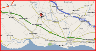
Dalton
Village, Dumfriesshire, Scotland;
A village is a small settlement about 10 miles south east of Dumfries and in the parish of Annanddale. Stands at Dalton Burn 4 miles south of Lockerbie.

Dalton;
West Yorkshire;
Is a township, in the parish of Kirk-Heaton, union of Huddersfield, West Riding of York; containing 3906 inhabitants. This place forms the eastern suburb of the town of Huddersfield, from which it is separated by the river Colne, and has become the centre of a widely extended branch of commerce, consisting of all kinds of fancy goods for waistcoating, trowsers, gowns, &c. The township includes Mold-Green, Dalton-Green, Dalton-Fold, Bradley-Mills, and some other scattered hamlets. It is situated approximately one mile southeast of the town centre between Moldgreen and Kirkheaton. Located in a small valley it is mostly comprised of housing, with a small amount of engineering firms to the northwest, surrounded by farmland used in the production of milk.

Dalton,
near Burton-in-Kendal, Lancashire, England
Is located about a mile east of Burton-in-Kendal and gives its name to Dalton Crags and Dalton Hall. Dalton is in the hundred of Lonsdale south of the Sands, N. division of the county of Lancaster, ½ a mile (S. E. by E.) from Burton-in-Kendal; containing 155 inhabitants. At the time of the Domesday survey, the manor was held by a Saxon chief named Gilmichael, and it was afterwards annexed to the manor of Burton; soon after the time of Richard I. it seems to have been granted to the family of Burton, and the lands were subsequently possessed by various families. The township comprises 2115a. 2r. 2p.; and is a rocky tract abounding in limestone, of which the high hill of Dalton Crag is almost entirely composed: there are two limekilns. Dalton Hall, formerly called Dalton Bank, is the seat of Edmund Hornby, Esq., some time M.P. for Preston; it is beautifully situated, about a mile and a half from the Burton station of the Lancaster and Carlisle railway, and commands fine views. The great tithes have been commuted for £183; the small tithes by a special act.

Dalton,
in HaẔafon, Israel
Also known as Daltoun, Shahar.

Dalton
Brook
New Hampshire.

Dalton
Brook
Vermont.

Dalton,
New York
Is a village in Livingston Co. New York

Dalton, Newcastle Upon
Tyne
Tyne And Wear, England

Dolton,
Devon, England
A medium size village, ever expanding with new houses being built. Dolton is located between the villages of Beaford, Winkleigh and Merton.
The village has many things to offer, including a grocery shop and electrical shop. The Village Hall is used nearly every day, for many of the local organizations.
There are three Public Houses, all supplying good food & drink. A daily bus service a few times a day into Barnstaple & Exeter and back.
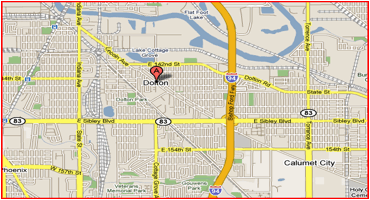
Dolton,
Illinois
Located in Cook County, 18 miles South of the Loop. Dolton and Riverdale were practically one community until each incorporated as a village in 1892. Dolton includes areas known as Berger, Greenwood, Marydale Manor, and Yard Center. The Dolton area is drained by the Little Calumet River, which forms part of Dolton's southern border as it flows west toward Blue Island, where it originally turned east and touched Dolton's northeast corner. Significant evidence of human habitation in the area of Dolton was found at the Anker Site on the north shore of the Little Calumet on the south edge of Dolton, which dates to about AD 1400 to 1500. Although the tribe could not be identified, the Miami and Illinois were known to have lived in the area during that period.
George Dolton settled where the old Indian trail (Lincoln Avenue) crossed the Little Calumet River in 1835 and operated a ferry with J. C. Matthews, who arrived in 1836. Dolton and Vincent Matthews operated the ferry until 1842, when a toll bridge was built that operated until 1856. This activity took place along Indiana Avenue in what is now the village of Riverdale and the Riverdale community of Chicago and was known as Riverdale Crossing.
Dolton's sons settled here, and it is for them that the town is named. A period of German immigration intensified in the late 1840s. The earliest industries were a distilling company and a lumber company located on the Calumet River. The coming of the railroads stimulated Dolton's growth. The 1850s began a period of rail expansion that has characterized Dolton's physical setting and brought in Irish Catholics who worked in constructing the railroads. From 1866 to 1910 the village was known as Dolton Station. Hay and grain were the earliest agricultural products. By the 1890s Dolton was a center for producing agricultural products for Chicago, such as potatoes, asparagus, cabbage, onions, sugar beets, eggplants, and lima beans. This early agricultural activity lead to the area's packing and canning industries.
In 1885 Dolton's clay deposits began to be exploited and eventually supplied three brick companies. In 1911 the brick workers conducted a successful one-month strike over an attempt to reduce wages. The mixture of railroads and the Little Calumet River proved to be a good site for industry. Dolton grew as a center for truck farming and manufacturing. It has produced bakery equipment, brass castings, shipping containers, cement, furniture, agricultural equipment, steel tanks, and chemicals. This diverse activity attracted an ethnically varied workforce. In the 1960s the Calumet Expressway (now the Bishop Ford Freeway) improved automobile and truck access to Chicago by two interchanges serving Dolton. In recent years large numbers of African Americans have moved to Dolton.

Dolton,
South Dakota
Dolton is a town in Turner County, South Dakota, United States. The population was 41 at the 2000 census.